The Water Framework Directive requires that an integrated monitoring programme be established within each river basin district.
These monitoring programmes will in many cases be extensions or modifications of existing programmes and will enable collection of the physical, chemical and biological data necessary to assess the status of surface and groundwater bodies in each river basin district
Further information on what is required by the Directive, based on an introductory guide published by the Foundation for Water Research, is provided in the accompanying Information pages:
- What is the Water Framework Directive?
- How is the Water Framework Directive being implemented?
- The Water Framework Directive - development of river basin management plans.
The UK Technical Advisory Group (UKTAG)
(http://www.wfduk.org) is a partnership of UK and Ireland environment and conservation agencies which provides co-ordinated advice on technical aspects of the implementation of the Directive.
Establishment of Monitoring Programmes
(Article 8)
Having established the criteria for the classification of water bodies it is essential to establish an integrated monitoring programme that embraces the physical, chemical and biological data needed to assess the status of surface and groundwater bodies in each river basin district. The Directive requires this to be in place by December 2006.
The Design of Monitoring Programmes
The detailed requirements for the design of monitoring programmes are given in the Annexes to the Directive.
The Annexes are provided in the text of the Directive which is available at:
https://www.gov.uk/government/policies/improving-water-quality
https://ec.europa.eu/environment/water/water-framework/index_en.html
Annex VIII gives an indicative list of the main pollutants and Annex IV deals with protected areas. Annex V provides details of how the programme should be designed, what should be monitored for and how the results should be presented.
Advice concerning interpretation of the complicated requirements has been prepared as part of the Common Implementation Strategy.
See the UK Technical Advisory Group website at:
It is expected that this advice will be modified once the Daughter Directives on Priority Hazardous Substances and on Groundwater are finalised.
Information needs drive the design of monitoring programmes and, although the principles are the same for both surface waters and groundwaters, it is convenient to list them separately.
Reasons for Monitoring Surface Waters
Monitoring information is needed for the following reasons:
- Classification of status of all water bodies or groups of water bodies.
- To support risk assessment procedures.
- Design of future monitoring programmes.
- Assessment of long-term changes whose causes are both natural and anthropogenic.
- Assessment of compliance with standards and objectives.
- Estimation of pollution load transfers across international boundaries or into seas.
- Assessing the efficacy of measures applied to water bodies designated as at risk.
- Ascertaining formerly unidentified reasons for failure to achieve environmental objectives.
- Assessing the impact of accidental pollution.
- Use in inter-calibration exercises.
Reasons for Monitoring Groundwater
Monitoring information is needed for the following reasons:
- Assessment of quantitative status of all groundwater bodies or groups of bodies.
- Estimating direction and rate of flow in groundwater bodies that cross international boundaries.
- Supporting impact assessment procedures.
- Assessment of long term trends whose causes are both natural and anthropogenic.
- Establishing the chemical status of groundwater bodies, or groups thereof, determined to be at risk.
- Investigation of upward trends in pollutant concentration and their reversal either due to natural causes or the application of positive measures.
The Nature of the Monitoring Programmes
The requirements for the design of surface water monitoring programmes illustrate the move away from the former static protocols implicit in the old directives to a more dynamic, risk-based approach. Here pressures due to hydromorphological and physico-chemical factors are linked to biological indicators of environmental quality.
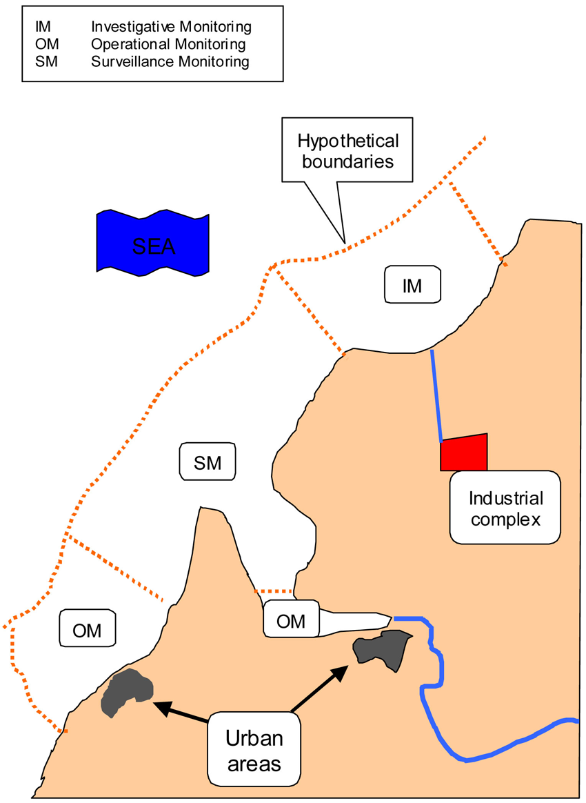
Accordingly, a network of monitoring sites is to be established to classify all water bodies using a combination of surveillance, operational and investigative monitoring of prescribed quality elements to satisfy the information needs identified above.
Essentially, surveillance monitoring will be used to validate risk assessments and determine long-term changes. Operational monitoring will be used to determine the status of water bodies identified as being at risk and how this changes as result of the programme of measures. Investigative monitoring will be used to establish reasons for failure.
The building of the monitoring network will be influenced by the nature of the individual water bodies, the analysis of the pressures and risks associated with them, the classification system to be applied and the extent of the existing monitoring network.
Examples of these pressures include the following:
- For rivers and lakes: nutrients, acidification, abstraction, morphology, alien species.
- Additionally for rivers: hazardous substances, pesticides, urban pressures, flow regulation, mine waters, pollution incidents.
- For transitional and coastal waters: nutrients, hazardous substances, organic enrichment, morphology, commercial fishing, alien species.
- Additionally for transitional waters: abstraction, industrial intakes and discharges.
- For groundwaters: nutrients, pesticides, minewaters, contaminated land, point sources, abstraction, urban pressures.
Figure 1 illustrates how these varying situations might influence the monitoring regime for a hypothetical system of transitional and coastal water bodies.
Outputs from the monitoring programmes
The monitoring programme will ultimately provide the following:
- Data from the reference sites to enable class boundary conditions to be established for all groups of water body types.
- The data to enable the classification of all individual water bodies.
- The means of monitoring progress with the implementation of the river basin management plans and associated programmes of measures and the basis for their subsequent revision.
- Early warning of new problems.
Note that the new monitoring programmes will not have been in place long enough to provide sufficient data for the initial river basin management planning exercise, so there will be significant reliance on data gathered through existing monitoring arrangements.
Figure 1
A monitoring regime for a hypothetical system of transitional and coastal waters
You are here:

Tel: +44 (0) 1628 891 589 Fax: +44 (0) 1628 472711
Registered Office: Allen House, The Listons , Liston Road, Marlow,
Buckinghamshire SL7 1FD, UK © 2015 FWR All rights reserved.
The Foundation for Water Research is a company limited by guarantee,
registered in England, No 525927 and a registered charity No 1086685.