Wetlands - pressures and impacts
Chemicals
Wetlands have a high capacity to tolerate chemical inputs such as fertilisers and pesticides from farming and oil and other hydrocarbons from roads and urban areas. However, persistent or extreme incidents of pollution will cause a deterioration in water quality, the development of algae and favour some plant species over others, such that the natural balance of the wetland habitat is damaged. This can be particularly persistent where phosphorus is transported into the wetland in soil eroded from farmland. Phosphorus is only slowly removed from sediment particles so its effects will be evident for a long period of time. When the source of the pollution is stopped, the wetland can usually recover over time.
Water Abstraction
Many wetlands are formed by groundwater. An increase in the use of groundwater for public water supply over the last 50 years has caused a fall in the water table in many wetland areas which have subsequently dried out and been adopted for agricultural use or forestry. The two types of groundwater-fed wetlands which occur in the UK are turloughs and meres. The change in water table level is much more rapid in turloughs than in meres. Turloughs flood in winter and dry up in summer and are found over carboniferous limestone in Northern Ireland and Wales. Meres do not have a regular rhythm of water level change and may remain in the same condition for several years.
UK Biodiversity Action Plan
http://jncc.defra.gov.uk/default.aspx?page=5155
Threats to UK Lowland Wetland Habitats:
(http://jncc.defra.gov.uk/page-5856)
Some wetland plant communities (for example, the calcareous fen sites in East Anglia) are critically dependent on groundwater. As a result, one of the Water Framework Directive groundwater quantitative tests is that groundwater abstraction should not cause significant damage at wetland sites. Ecological impacts can be mitigated through water level or site management. An example is through Water Level Management Plans (WLMPs) agreed between the Environment Agency and Defra. The Environment Agency has focussed delivery of its WLMPs on Sites of Special Scientific Interest (SSSIs).
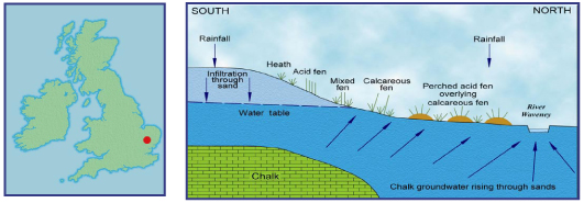
There are well documented examples such as Redgrave and Lopham Fens in Suffolk. This is an area where groundwater abstraction had seriously impacted on the quality of the wetland habitat. Co-operation between the Environment Agency, Essex and Suffolk Water, English Nature and the Suffolk Wildlife Trust has brought about a rebalancing of abstraction for water supply with the need to conserve an important habitat. The diagram illustrates the flow of water in the fen, which is spring fed, when not impacted by groundwater abstraction.
http://www.groundwateruk.org/downloads/low_river_flows_and_wetlands.pdf
This is an area where groundwater abstraction had seriously impacted on the quality of the wetland habitat. Co-operation between the Environment Agency, Essex and Suffolk Water, English Nature and the Suffolk Wildlife Trust has brought about a rebalancing of abstraction for water supply with the need to conserve an important habitat. The diagram illustrates the flow of water in the fen, which is spring fed, when not impacted by groundwater abstraction.

Image courtesy of the Groundwater Forum
Section through Redgrave and Lopham Fen. The section shows the natural groundwater flow situation. Abstraction of groundwater from boreholes in the Chalk aquifer reverses the flow direction.
Wetlands are also impacted by the abstraction of water from rivers. Areas of wetland-type habitat often occur along the banks of rivers and where rivers enter lakes or the sea. When the level of water in the river rises and falls rapidly due to pumped water abstraction, the wetland is subject to rapid drying and re-wetting cycles which stresses plants and can cause bank erosion to occur. Equally, the creation of a dam and reservoir for water supply or power generation purposes can negatively impact wetland areas where too little water is left in a river after it has been abstracted upstream. When this base flow of the river is very low, insufficient water is fed to wetlands associated with the river causing them to dry and become invaded by non-wetland plant species, resulting in degradation of the wetland habitat. In England the Environment Agency seeks to understand the water balance of their catchments and what water may be available for future use through Catchment Abstraction Management Strategies (CAMS).
Land Drainage
Wetland soils are fertile, flat and have a ready water supply, the level of which can be controlled by the digging of drainage ditches, pumping and building embankments. This makes them attractive as agricultural land. In the past in the UK, very large areas of wetland were drained or partially drained (some 12 million acres between 1840-1890) to provide both arable and grazing farmland, eg. the Fens of East Anglia and the Somerset Levels. Areas drained for grazing can still be valuable wetland habitats since the level of drainage is generally less severe than for arable, and management inputs such as fertiliser and pesticides are fewer. The type of wetland habitat has, nevertheless, been changed from its natural form. Many wetlands have also disappeared as a result of peat extraction for use in the horticultural industry.
You are here:

Tel: +44 (0) 1628 891 589 Fax: +44 (0) 1628 472711
Registered Office: Allen House, The Listons , Liston Road, Marlow,
Buckinghamshire SL7 1FD, UK © 2015 FWR All rights reserved.
The Foundation for Water Research is a company limited by guarantee,
registered in England, No 525927 and a registered charity No 1086685.