
Page 51 - Freshwater-Biology-and-Ecology-Handbook
P. 51
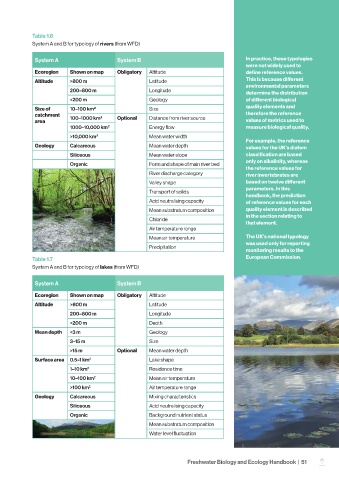
Table 1.6
            System A and B for typology of rivers (from WFD)

             System A                     System B                                     In practice, these typologies
                                                                                       were not widely used to
             Ecoregion    Shown on map    Obligatory  Altitude                         define reference values.
             Altitude     >800 m                     Latitude                          This is because different
                                                                                       environmental parameters
                          200–800 m                  Longitude                         determine the distribution
                          <200 m                     Geology                           of different biological
             Size of      10–100 km2                 Size                              quality elements and
             catchment                                                                 therefore the reference
             area         100–1000 km2    Optional   Distance from river source        values of metrics used to
                          1000–10,000 km2            Energy flow                       measure biological quality.
                          >10,000 km2                Mean water width
                                                                                       For example, the reference
             Geology      Calcareous                 Mean water depth                  values for the UK’s diatom
                          Siliceous                  Mean water slope                  classification are based
                                                                                       only on alkalinity, whereas
                          Organic                    Form and shape of main river bed
                                                                                       the reference values for
                                                     River discharge category          river invertebrates are
                                                     Valley shape                      based on twelve different
                                                                                       parameters. In this
                                                     Transport of solids
                                                                                       handbook, the prediction
                                                     Acid neutralising capacity        of reference values for each
                                                     Mean substratum composition       quality element is described
                                                                                       in the section relating to
                                                     Chloride
                                                                                       that element.
                                                     Air temperature range
                                                     Mean air temperature              The UK’s national typology
                                                                                       was used only for reporting
                                                     Precipitation
                                                                                       monitoring results to the
            Table 1.7                                                                  European Commission.
            System A and B for typology of lakes (from WFD)

             System A                     System B

             Ecoregion    Shown on map    Obligatory  Altitude
             Altitude     >800 m                     Latitude
                          200–800 m                  Longitude
                          <200 m                     Depth
             Mean depth   <3 m                       Geology
                          3–15 m                     Size
                          >15 m           Optional   Mean water depth
             Surface area  0.5–1 km 2                Lake shape
                          1–10 km 2                  Residence time
                          10–100 km 2                Mean air temperature
                          >100 km 2                  Air temperature range
             Geology      Calcareous                 Mixing characteristics
                          Siliceous                  Acid neutralising capacity
                          Organic                    Background nutrient status
                                                     Mean substratum composition
                                                     Water level fluctuation


                                                                   Freshwater Biology and Ecology Handbook  |  51
                                                                                                                 –